
Clouds larger than memory
A Potree-style out-of-core LOD octree streams surveys far bigger than VRAM. Conversion from LAS is lossless and verified point-for-point — millimetre precision holds across multi-kilometre georeferenced extents.
Load a laser-scanned LAS survey and draw real geometry over it — in VR at true scale, or on the desktop. Build surfaces, contours, profiles and volumes, then export DXF, LandXML, meshes, reports and georeferenced orthophotos.
VRCAD is a native C++20 application built on OpenXR and Vulkan — no web technologies, no cloud round-trip. The whole pipeline runs on your machine.
A Potree-style out-of-core LOD octree streams surveys far bigger than VRAM. Conversion from LAS is lossless and verified point-for-point — millimetre precision holds across multi-kilometre georeferenced extents.
An OpenXR stereo session renders the survey at 1:1 so you can walk the site and draw where you stand. The VR session runs its own Vulkan device and shares one project with the desktop view.
Lines, polylines and shapes drawn with real snapping against the cloud and against your own geometry. Work planes, sections, layers and guides keep long survey jobs organised.
Crop boxes, crop polygons and section slabs isolate what matters. Assign and filter by classification, delete noise, and step back through it all with full undo and redo.
Build surfaces, generate contours and profiles, and compute cut and fill volumes — with a convergence check at twice the grid spacing so a number you report is a number you can defend.
DXF, LandXML, meshes, reports and streaming tiled BigTIFF orthophotos that are never memory-bound. A live COM link drives a running AutoCAD session directly from VRCAD.
Eye-Dome Lighting, SSAO, normal shading and a Sobel depth-edge outline — plus round sprites, soft splats and 3D octahedrons — turn an untextured cloud into geometry you can actually read.
A dependency-free LAS 1.0–1.4 reader and writer covering point data record formats 0–10, with streaming I/O. Command-line tools convert, inspect and generate datasets outside the GUI.
A simulated OpenXR runtime runs the entire VR session — menus, radials, interaction — on the desktop with no hardware attached. Review VR work from any machine.
Section slabs and crop polygons cut straight into the cloud so you can work on one structure at a time. Selections carry across to classification, editing and export, and every destructive step is undoable.
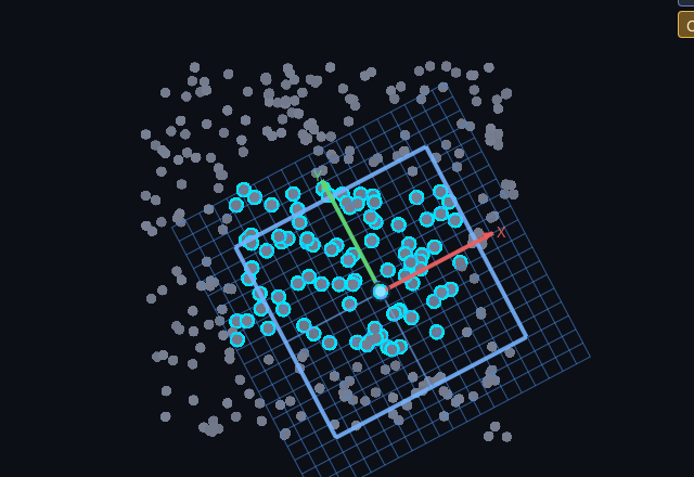
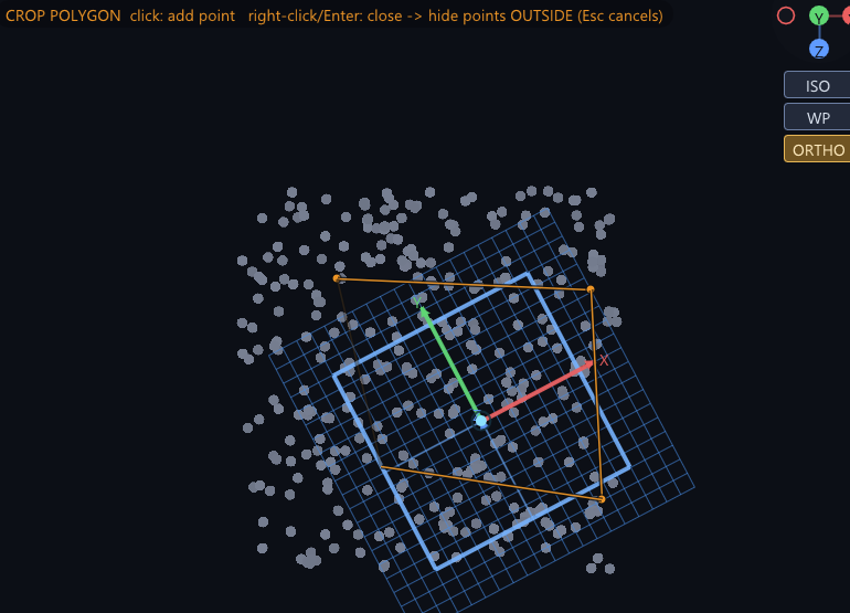
Not mock-ups — these are working sessions on live project data. Click any of them to see it full size.

The same pipeline — scan in, geometry over it, deliverable out — applied across surveying, infrastructure and heritage work.
Surfaces built from a scanned embankment, differenced against design to give cut and fill quantities with a convergence check on the reported figure.
Ground classified out of a raw aerial scan, contours generated at fixed intervals, and the whole sheet delivered as DXF alongside a georeferenced orthophoto.
Section slabs taken through each pier, geometry drawn against the scan in VR at true scale, and deviations from the design model measured directly in the cloud.
Profiles pulled at regular chainage along a bored tunnel, with overbreak and underbreak read off the surface and exported straight into the client's CAD package.
A dense terrestrial scan traced into 2D elevation linework on work planes matched to each façade, then issued as measured drawings.
A congested plant scan reviewed at true scale in the headset, where clashes and clearances are obvious in a way they never are on a flat screen.
Working on something VRCAD should handle? Tell us about it — we're interested in hard datasets.
A per-user install — no administrator rights required. Everything works for 30 days; after that the application keeps running and only exports are gated.
Version 2.8.3 · 64-bit installer · 12.6 MB
Download VRCAD-Setup-2.8.3-x64.exe1d65b577c704f3f70765db10474191138ac10f27ff028106fe0ee5afb9545c29
Windows SmartScreen will warn you the first time you run this installer — it is not yet code-signed. Choose More info › Run anyway, and check the SHA-256 above against the file you downloaded if you want to be certain it is intact.
%LocalAppData%VRCAD renders with Vulkan, so Windows Mixed Reality headsets must run through SteamVR's OpenXR runtime. The desktop application does not need a headset at all.
The application, its runtime libraries, and the full 14-chapter user manual — reachable from Help > User manual.
A 30-day trial with every feature unlocked. Licences are Ed25519-signed, node-locked and issued offline — nothing phones home.
A licence runs forever on the versions it paid for. The maintenance window controls which future builds it covers.
Questions about licensing, a dataset you want to test, or a workflow you need supported — write to us directly and a person will answer.
edcofu.vrcad@gmail.com We reply to every message